Carthography and Empire - The World on View
The Roman Empire and the Islamic Empire conquered and ruled large areas of land. What did emperors, caliphs, and governors know about the lands they actually ruled? What cities and tax-rich regions, what mountains, valleys, river systems did they have to oversee? Where were they located? While land surveying for purposes of land distribution, cultivation, and taxation was well developed, and astronomical observation and mathematics were at such a high level that they could measure the spherical shape of the planet, knowledge of the geological and civilizational features of the earth was still in its infancy, but necessary. Maps, however, seem to have a different origin than fiscal or astronomical concerns. Itineraries and road maps were not only verbalized, but put on a graphic. The best known map of late Roman antiquity was the map copied around 1200 CE and kept for a long time in the family of the humanist Konrad Peutinger. In the Islamic Empire, cartography had similar roots, beginning with itinaries and their visualization, and in some cases linked to astronomical measurements. In our back-to-back lecture the outstanding speakers offer a discourse between the efforts of the two empires.
Roman Cartography and the Empire
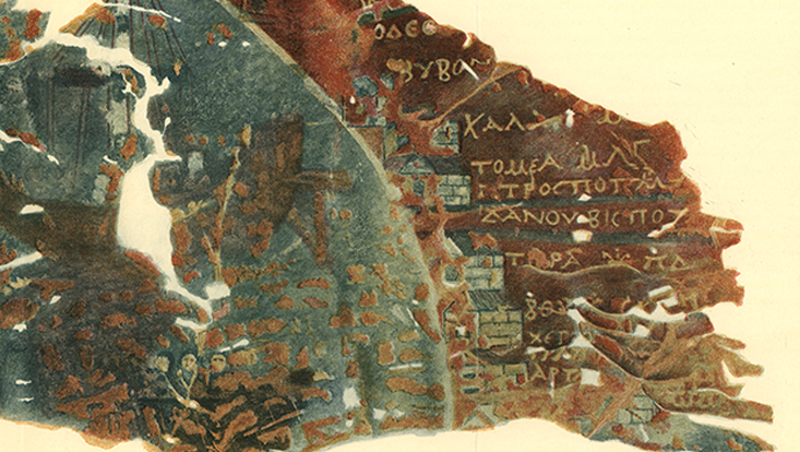
Our sole ancient map of the Roman empire – the ‘Peutinger’ map – is a large, impressive achievement which naturally merits close attention. Even so, it and related fragmentary survivals leave open the underlying greater issues of what maps meant to Romans, and to what extent they created and used them. To be sure, from the Hellenistic period onwards mapping concepts and data were to hand, developed by Eratosthenes and successors at Alexandria. One of the latter, Ptolemy in the second century CE, devised a neat new format for recording latitude and longitude co-ordinates. This was for certain adopted by designers of portable sundials, but still (it seems) Romans hardly became map-conscious. Why not, and how far such defective vision (as we might consider it) mattered, are prime questions in the short lecture.
 Richard Talbert (The University of North Carolina at Chapel Hill), now retired, is a Cambridge-trained ancient historian who developed a wide range of interests while teaching in the United Kingdom (1970-85), Canada (1985-88), and the United States (1988-2021). How Romans viewed and mapped their world is a major topic on which he has published extensively: see his Rome’s World: The Peutinger Map Reconsidered (Cambridge, 2010), Roman Portable Sundials (Oxford, 2017), and World and Hour in Roman Minds: Exploratory Essays (Oxford, 2023). A related effort has been to create an unprecedented modern cartographic perspective in the Barrington Atlas of the Greek and Roman World (Princeton, 2000), and through the work of the Ancient World Mapping Center (https://awmc.unc.edu), which he established. Further information in his Wikipedia entry.
The Islamicate World in Pieces. Envisioning the Abbasid Realm through the Book of Routes and Realms (10th c.) by Dr. Nadja Danilekow (Freie Universität Berlin)
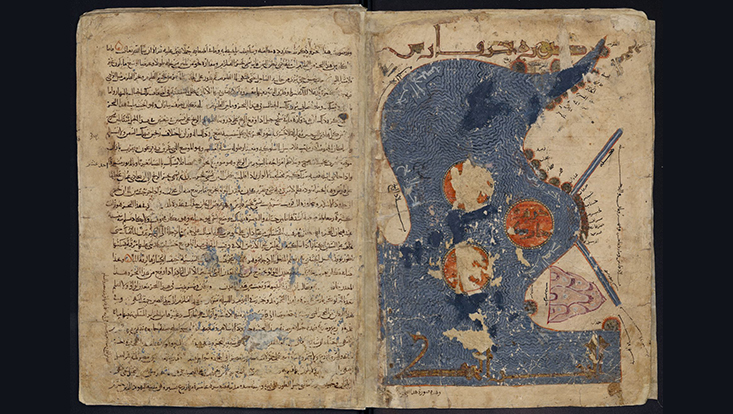
The Arabic Book of Routes and Realms (Kitāb al-Masālik wa-l-Mamālik) preserves the first maps we have from the Islamicate world. Created in the tenth century by al-Iṣṭakhrī (fl. tenth c.),
the treatise described the Islamicate world from al-Andalus to Sindh. In addition to details about events, trade and customs, the treatise holds one world map and twenty regional maps that accompany the chapters about the twenty Islamicate regions. The presentation will analyze al-Iṣṭakhrī's map design and what idea of space he aimed at communicating through his images and text.
<strong
 Nadja Danilenko is the demand manager in the IT department at Freie Universität Berlin. Previously, she was an adviser in Strategic Initiatives at the Head Office of the Helmholtz Association and a Principal Investigator at the Cluster of Excellence “Understanding Written Artefacts: Material, Interaction and Transmission in Manuscript Cultures” at the Universität Hamburg. She completed her PhD in 2018 in Islamic Studies at the Freie Universität Berlin (BGSMCS). Her thesis examined the al-Iṣṭakhrī’s Book of Routes and Realms and its transmission. Since 2016, Nadja hosts a German podcast about the history and culture of the Islamicate world that caters to a broad audience (“tell me a history – erzähl mir eine Geschichte,” https://tellmeahistory.net).